Whut u’m doin’ is mur mpurtant tun whut yer doin’.
– A heavily armed, angry, poorly educated hunter
who acted like any mammal was fair game |
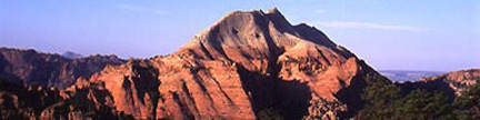
Electric Peak A – 13,598 feet
The highest peak on the north-central crest of the Sangre de Cristo, Electric commands respect, however the peak provides an easy ascent. |
 |
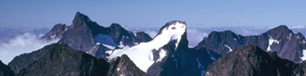
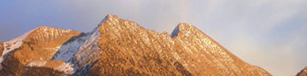
Electric Peak seen from the south across Cotton Creek
The upper part of the Northwest Ridge Route is the left skyline
You can see Horsethief Basin above Cotton Creek in the lower center of the photo
Gerry took this photo from Mount Owen on 10/17/04 |
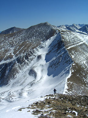 |
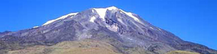
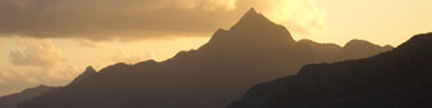
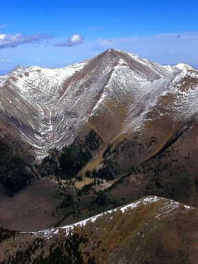
Electric Peak seen from the north
The upper part of the Northwest Ridge Route rises above “Electric Pass”
to Point 13,220, which is at the top of the snowslope, and beyond to the top of Electric
Gerry took this photo from Lakes Peak on 3/5/06 |
USGS 7.5’ Quadrangles: Electric Peak, Valley View Hot Springs
Northwest Ridge – 13 miles RT, 4,978 feet net, 5,660 feet total, Class 2 |
| One of the higher peaks in the northern Sangres, Electric Peak provides a sturdy hike for the fit.
Start at the Major Creek Trailhead
and follow the Major Creek Trail south to a shoulder overlooking the lower Major Creek drainage.
Since private property blocks access directly up Major Creek, you must now descend a series of switchbacks
to reach Major Creek at a point east of the private property. This obtuse beginning to your hike adds 2 miles
and 520 feet of gain to your roundtrip. Once in the Major Creek Drainage, simply follow the trail,
which stays on the creek’s north side. Busy beavers make your up-valley hike more difficult
with their fresh cut aspens which criss-cross the trail and their overflowing dams which flood the trail.
Additionally, the horse trains that frequent this trail churn the wet spots into bigger bogs.
At treeline, continue east up the switchbacking trail to reach 12,460-foot “Electric Pass.”
Your long Class 1+ trail approach is over. Now for the Class 2 climb. From the pass turn south (right),
and climb 760 feet up talus to the summit of Point 13,220, from which you can see the remaining route
to Electric. Descend easy slopes to the broad, 13,140-foot saddle between Point 13,220 and Electric,
then climb 380 feet southeast up talus on Electric’s northwest ridge to reach the summit. |