4. Fletcher Group
- The unnamed lake high on Pacific Peak’s east side at
13,420 feet was officially named Pacific Tarn in January 2004. This tarn is
referenced on Pacific’s Northeast Slopes Route on Page 60, the East Ridge
Route on page 61 and the Southeast Slopes Route on page 62. Pacific Tarn is
now officially the highest lake in the United States.
6. Mount Silverheels
- There are now No Trespassing signs above the Scott Gulch and South Scott Gulch Trailheads
discussed on page 79. It is best to avoid using these trailheads and use Route 6.1,
the South Ridge Route on Mount Silverheels, which starts at the Beaver Creek Trailhead.
- The driving mileages to the Beaver Creek Trailhead for Mount Silverheels on page 79 are incorrect.
The correct text is, “Go 0.3 mile northeast on Fourth Street to a T-junction, turn north onto
Bogue Street and go one block north to a stop sign. Go straight through the stop sign and continue
north on what is now Beaver Creek Lane. Turn east (right) onto FS 413 at mile 2.8 and go east
to a parking area and Forest Service gate at mile 3.1. This is the winter trailhead. From the gate,
go north on FS 659 to the unmarked Beaver Creek Campground, which is just a pullout on the road’s
east side at mile 5.0. Continue north on FS 659 to the trailhead at mile 5.3.”
7. Gemini Group
- Routes that originate at the Sacramento Creek Trailhead, which is described on page 85,
and go west up Sacramento Creek, are no longer accessible.
They are blocked by private property that is guarded by a sanctimonious landowner.
The USFS has not been able to help the public gain access to Sacramento Creek.
Do not use the Sacramento Creek Trailhead.
- On page 87, lines 3 and 6 should read northeast instead of southeast.
8. Holy Cross Ridge
- The White River National Forest Ranger Station has moved from the referenced location
at Main and Harrison in the center of Minturn to a spacious location just south of exit 171
on Interstate 70. Accordingly, the directions to the French Creek Trailhead on
page 96 should read, “A few miles west of Vail, take exit 171 off Interstate
70. From the U.S. 24-Interstate 70 junction, go 2.0 miles south on U.S. 24
to Main and Harrison in the center of Minturn, continue 10.6 miles south on
U.S. 24, turn southwest (right) onto the Gold Park Road (FS 703) and measure
from this point.”
13. Emerald Group
- The location of the 4WD parking spot above the Rockdale Trailhead is mis-marked on
Map 13 on page 125 and Map 14 on page 132. The correct position is in a meadow
at 10,895 feet, which is 0.25 mile south of the marked position.
15. “North Carbonate”
- Our unofficially named 13,870-foot “North Carbonate,” headlined on
page 139, has been officially named Cronin Peak.
17. Kat Carson Group
- Our unofficially named 13,980-foot “Kat Carson,” headlined on page 158,
has been officially named Columbia Point in memory of the crew of the spaceship Columbia,
which broke apart during re-entry on Feb 1, 2003.
- There have been issues with the Spanish Creek Trailhead discussed on page 151. It’s not
clear just what the status is for hiking through the Baca estates, but do not park your
vehicle on private property without permission from the landowner.
18. California Group
- The Upper Huerfano Trailhead is mis-positioned on Map 18 on page 162.
The correct location is 0.5 mile north of the marked position, and is at
10,660 feet, not 10,680 feet. The trailhead is just north of and above a
large meadow, which shows on the map. This error means that distances from this
trailhead are 1.0 mile RT longer than indicated, and that, because of the initial
drop to the meadow, the elevation gains from this trailhead are 140 feet
more than indicated. The Huerfano River Trailhead on Map 20 on page 168
in Gerry’s Fourteener book is positioned correctly.
19. Red Mountain
- The western approach to Red Mountain is now owned by the Cielo Vista Ranch.
They do accept some reservations each year for climbs of Red, Culebra and neighboring peaks.
They have been charging a fee of $100 per day per person for climbs of Culebra and $150 per day
per person for Culebra and Red. Contact the ranch at cielovistaranch@hillranch.com
or 254-897-7872 or 254-897-9537 for more information.
21. “Thunder Pyramid”
- There is an improvement to the beginning of the route above the trail. There are several ways to do this,
but we feel that this is the best option. Do not leave the trail right after
crossing to the creek’s east side at 10,500 feet. Instead, continue south on the trail for 250 yards
after crossing the creek. Leave the trail where it reaches a small meadow and you can look clearly up to the
east at “Thunder Pyramid,” and the cliffed slopes leading up to the hanging valley below the peak.
Study the route from here, since you can see the gullies through the lower cliffs as well as the white gully
on the peak above. Leave the trail, go up grassy slopes, climb through a narrowing gully in an initial cliff,
then continue straight up the slope through another loose rock gully through the largest cliff band. Continue up
sometimes steep grassy slopes above this gully, zigzagging as needed, to reach the hanging valley above at
11,500 feet. Continue on to the White Gully above as described in the text.
28. Jones Group
- Our unofficially named 13,806-foot “American Peak,” headlined on page 235,
has been officially named American Peak.
29. Vestal Group
- The Durango-Silverton Railroad now charges $81 roundtrip no matter where you get on or off. No exceptions.
They also charge you an additional $10 for your backpack.
With this ticket, you can indeed ride the train from Durango to Silverton and back to Durango.
So, for example, you could ride from Durango to Needleton, do your backpack, reboard the morning train at Needleton,
go to Silverton, have a burger, and ride the train back to Durango in the afternoon.
You can still hand the conductor $41 cash for a one-way ride out from Elk Park or Needleton in either direction.
Not all trains stop for backpackers, and the schedule changes with the season,
so check with the railroad before making your plans.
30. Pigeon Group
- There is a small change to the North Pigeon Creek Approach (30.A3), Ruby Creek Approach (30.A4), and Noname Creek Approach (30.A5).
The tree across the trail in Camper’s Meadow has been sawed so there is no longer a need to go around its east end.
The tree is decomposing, but is still a good landmark.
- There is a small change to the Ruby Creek Approach (30.A4).
The five-foot rock downclimb as the trail enters the Ruby Creek drainage is now avoidable. The trail goes 40 feet down and around the
rock obstacle, but there is still a steep spot to contend with. The high route beyond this point is now the preferred trail.
- When dry, there is a Class 3 route to the top of Pigeon Peak that avoids the Class 4 chimney we describe on page 273.
This face collects snow quickly after late summer and early fall storms, so don’t wait too long for this one.
There are multiple starts to this hard-to-see route. The easiest start is down to the right well below the chimney
and angles up to the left on a ramp. You can also reach this ramp via a short Class 3 scramble that angles up from the left.
Above the ramp, the route zigzags up the face; follow the path of least resistance and look for cairns.
When the slope angle relents, angle right to reach the upper southwest ridge in a small saddle with a red dirt streak crossing it.
Turn left and scamper up Class 2+ boulders on the south side of the ridge to the summit.
Pigeon’s highest point is an amazing boulder perched above the vertiginous east face.
This boulder is visible from many vantage points to the east and many sure-footed souls have struck a pose on it.
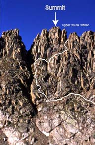
- The route line for Route 30.10 on the photo of Jagged Mountain on page 277 is not quite right.
Here is a more accurate line.
32. Vermillion Peak
- 13,894-foot Vermilion Peak, headlined on page 291, is misspelled throughout the book and list.
It is Vermilion, not Vermillion.
33. Gladstone Peak
- Approach 33.A1 - the Silver Pick Basin Approach on page 300 has changed.
After a period of closure, there is now a new Forest Service trailhead 1.3 miles above
the old Wilson Mesa Trailhead referenced on page 297. The Silver Pick Basin Approach
referenced on page 300 is similar, but has changed slightly to avoid
the remaining private property in the basin. The new approach route is well signed.
- In the description for the Navajo Lake Trailhead on page 299, the distance
from the Rico Post Office to the turn onto the Dunton Road is 6.5 miles, not 9.5 miles.
- In the description for the Navajo Lake Trailhead on page 299,
the sentence in the middle of the second paragraph should read,
“...descend west toward the West Dolores River, turn hard north (right) at mile 7.2
(37.8029° -108.0639°), go north on a spur road and reach the trailhead at mile 7.3.”
|